In addition to traditional navigation methods, two more technologically advanced methods of navigation were also installed on the meteor. The SCR-720 radar, intended for interception of enemy aircraft and GEE, an early precursor to LORAN.
GEE is based upon a radio round trip time of flight measurement. Relying on known fixed ground-station locations with an accurate time-base, the time difference of arrival, TDOA, between two stations places the receiver on a hyperbola. Depending upon the ground station locations, as few as two TDOA measurements between 3 stations could yield a location fix.
The accuracy that the system could achieve in skilled hands was impressive: with a fix possible in only 15 seconds with an accuracy of plus or minus 25 feet at sea level. An accuracy which compares pretty favorably with GPS, although without the same level of convenience!
The basic operation of GEE is described with exceptional clarity in the following video.
In summary the operator aligns the A-trace indicator, originating from the Master. This allows the Slave signals from the B and C stations to be plotted relative to the time at which the A-signal was received.
Lines of constant delay are plotted in ‘GEE units’ (each of 66.66 us), with the Time Difference of Arrival (TDoA) between A and B station shown in in red lines and the TDoA between A and C stations shown in green.
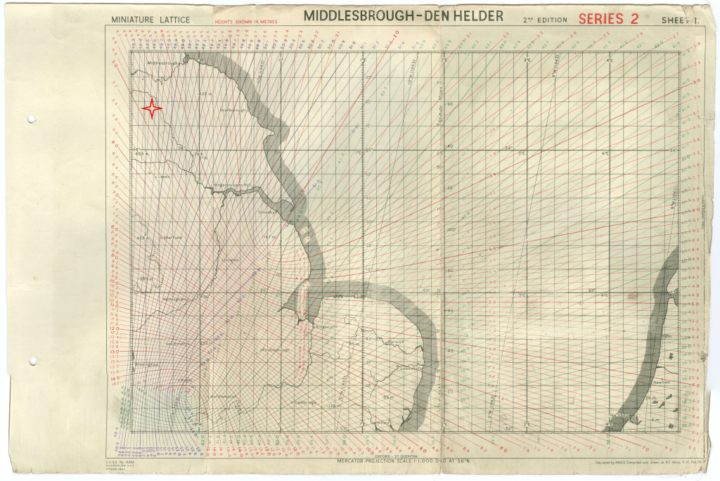
The map below shows the TDoA hyperbolas for the Eastern Chain. Here the GEE stations are located at:
- Daventry: appears to be the Master as it is the lower focus of the red curves and also the focus of the green and purple curves (52.262908, -1.136939).
- Stenigot: the upper focus of the red (B) lines (53.324494, -0.114206).
- Ventnor: the Easterly focus of the green (C) curves, off the map edge (51.115347, -0.717024).
- Clee Hill: In Shropshire and off the Westerly side of the map and the opposite focus of the purple (D) plot (52.397631, -2.592234).
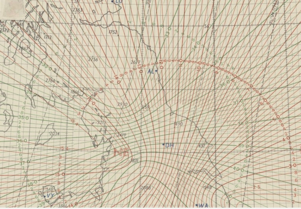
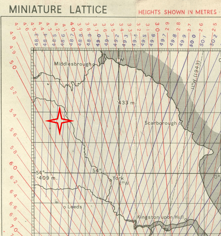
The following image is a close-up of the GEE plot near RAF Leeming, which shows that the D-plot of the TDoA curves would have almost aligned with runway 34/16 at 48.65 GEE units.
GEE as an Approach Aid
This prompted some investigation into the use of GEE to let down through low visibility conditions. Indeed, many excellent first hand accounts are told in [3] detailing how many pilots would take a GEE fix on the threshold of the runway and use GEE as an approach aid upon their return.
Other GEE Charts
The Smithsonian has another chart from 1944 available [4]
References
[3] John W. Howland, GEE AS A HOMING DEVICE, http://www.91stbombgroup.com/91st_tales/06_gee_homing_device.pdf
For information on the GEE Mk2 predecessor, see this inofmation in GEE Mk1:
[5] http://www.buildalanc.co.uk/gee_detail.htm
GEE Mk2 was followed by GEE-H, based upon RTToF rather than TDoA, an explanation can be found here:
[6] https://www.radarpages.co.uk/mob/navaids/geeh/geeh1.htm
A good summary of GEE and other navigation technologies from the era:
[7] https://flyingthebeams.com/early-radio-nav-1926-1960#445b1643-fac8-4e38-9d4f-9786f0771925
